
admin
Web scraping and mapping urban data to support urban design decisions
Abstract
Cities generate data in increasing speed, volume and variety which is more easily accessed and processed by the advance of technology every day. Consequently, the potential for this data to feed back into the city to improve living conditions and efficiency of utilizing resources grows. Departing from this potential, this paper presents a study that proposes methods to collect and visualize urban data with the aim of supporting urban design decisions. We employed web scraping techniques to collect a variety of publicly available data within the Kadıköy municipal boundaries of Istanbul and utilized a visual programming software to map and visualize this information. Through this method and superposition of our resulting maps, we visually communicate urban conditions including demographic and economic trends based on online real estate listings as well as spatial distribution and accessibility of public and commercial resources. We propose that this method and the resulting visualizations present valuable potential in supporting urban design decision-making processes.
Keywords
Geospatial data, Urban data, Urban design decision support, Web scraping.
Form-based codes for Istanbul, pt I
Location Istanbul, Turkey
Year 2018-2019
Client Istanbul Metropolitan Municipality
Job description Analysing existing and projected urban conditions in order to establish a design code for urban regeneration
Function Urban planning
Project area 348 ha
Consultant Kentsel Strateji
Collaborators Super Eight
The urban design proposal is a part of an ongoing research project in order to create a form-based code system for Istanbul. The design studies are to test out the potentials, limitations and shortcomings of the current regulations. The second phase of the study will be coming up with form-based codes for future urban regeneration projects in Istanbul, in conjunction with current practices in the world and unique realities of the city.

Analyses of existing urban setup.

Schematic design approach.

Site plan.

Strategies of one of the sub-regions.


Central Kartal Urban Design and Codes
Location Istanbul, Turkey
Year 2018
Client Kartal Municipality
Job description Translating the conceptual design project into applicable development projects
Function Urban planning
Project area 390 ha
Consultant Kentsel Strateji
Collaborators About Blank, Bits ‘n Bricks
Previously designed by Zaha Hadid Architects in 2006, central Kartal is in the brink of transformation. This urban planning project is a proposal that combines the ZHA’s original conceptual approach, the existing urban dynamics, future projections and applicability.


3D envelopes are created according to existing regulations and established height and massing strategies.


Following the design proposal, the design and implementation approaches are transformed into design codes in order to establish a guideline for architects that will design individual projects.


Public Transportation Maps for Zonguldak
Location Zonguldak, Turkey
Year 2018
Client Kivi Stratejik Planlama
Job description Geovisualisation
Status Ongoing
Zonguldak is a northern city of Turkey, located 4 hours to the east of Istanbul. The city has a formidably challenging topography resulting in a unique street network, therefore peculiar public transportation routes.
Currently, two modes of public transportation used in the city are buses and dolmuş‘s. A dolmuş (“stuffed” in Turkish) is a mini-bus carrying a maximum of 9 people at a time, is similar to a shared-taxi that runs a set route. The dolmuş‘s do not have a schedule as they only depart when all of the seats are full, hence the name. Additionally, they do not have formal stops, but rather they allow the passengers to get off wherever they need on the route. Dolmuş is particularly common paratransit method in Turkey.
While the buses run on established timetables, when it comes to having bus stops they act similar to that of a dolmuş: They only have a start and end stop. These stops do not have any kind of information regarding the bus/dolmuş routes, and unless you are a local it is next to impossible to find your way around the city using public transport.
The city is currently undergoing a transformation and there are several urban scale development projects, aiming to make the city a touristic attraction. This requires bettering the wayfinding system throughout the city as well.
In order to create the public transportation maps, all 24 bus routes and 28 dolmuş routes were recorded with a high-precision GPS device by local students. The routes were then simplified Vignelli style. Since there is little information to show (ie. not having bus stops, connections, transfers), we regard this project as ongoing and the maps will be updated as the city develops its infrastructure.

The bus map.

The dolmuş map.


Tourism Potential Mapping for West Black Sea Region
Location Zonguldak, Bartın and Karabük, Turkey
Year 2018
Client Kivi Stratejik Planlama
Job description Geospatial analysis and visualisation
Function Strategic planning for tourism master plan
Located in the west-northern shore of Turkey, Zonguldak has a pristine natural beauty. What makes the city unique though, is its long-standing industrial history. The city has developed around coal mines that have been operational since 1829, and the mines and relevant structures are still the city’s most defining characteristics.
In order to fulfill the city’s tourism potential, Kivi Stratejik Planlama has been working on a regional tourism master plan. We have prepared a series of maps in order to understand the current status. Maps include Zonguldak and two of its important neighbours, Bartın and Karabük. See some below.

Zonguldak, Karabük and Bartın.

Attraction points of three cities according to the official tourism website, kulturportali.gov.tr.
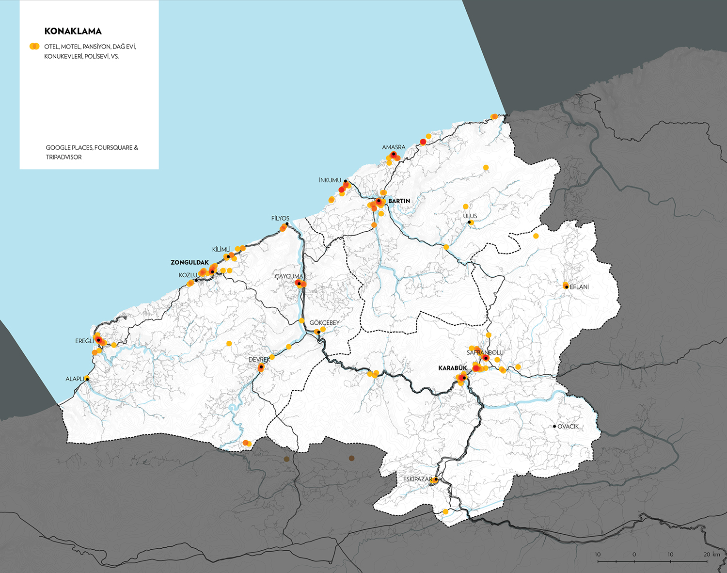
All types of lodgings; collected from Google Places, Foursquare and Tripadvisor and superposed.
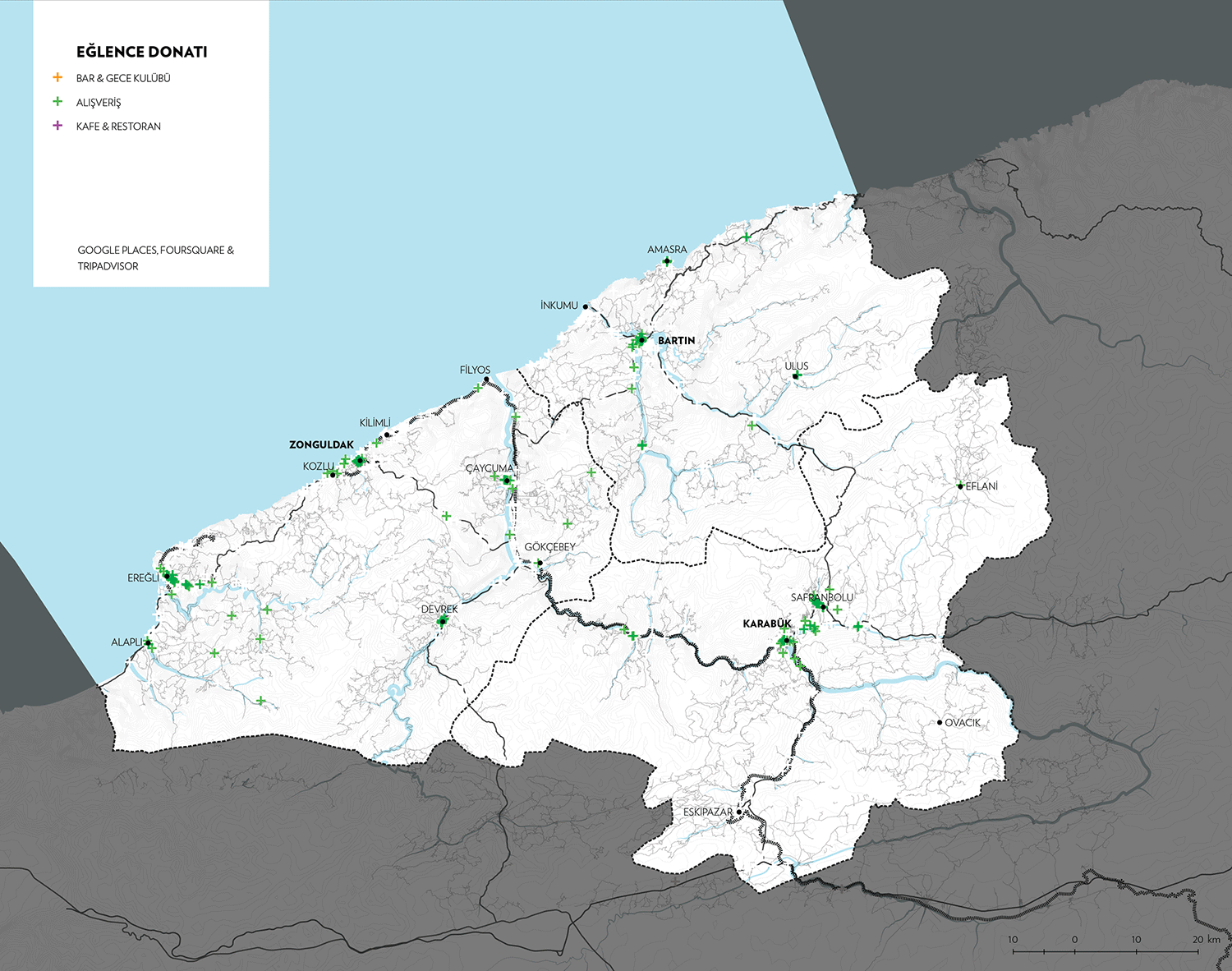
Cafes and restaurants, bars and shopping points; collected from Google Places, Foursquare and Tripadvisor and superposed.
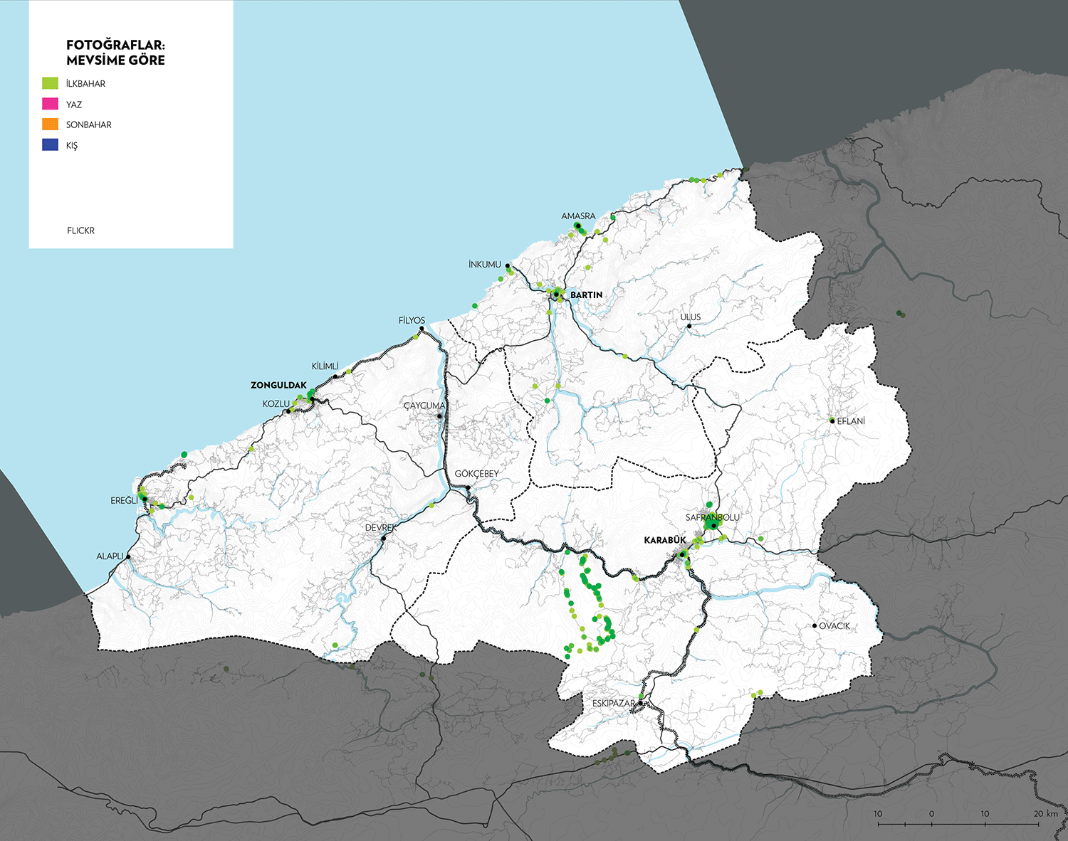
Flickr photos, according to seasons (spring, summer, autumn and winter, respectively).
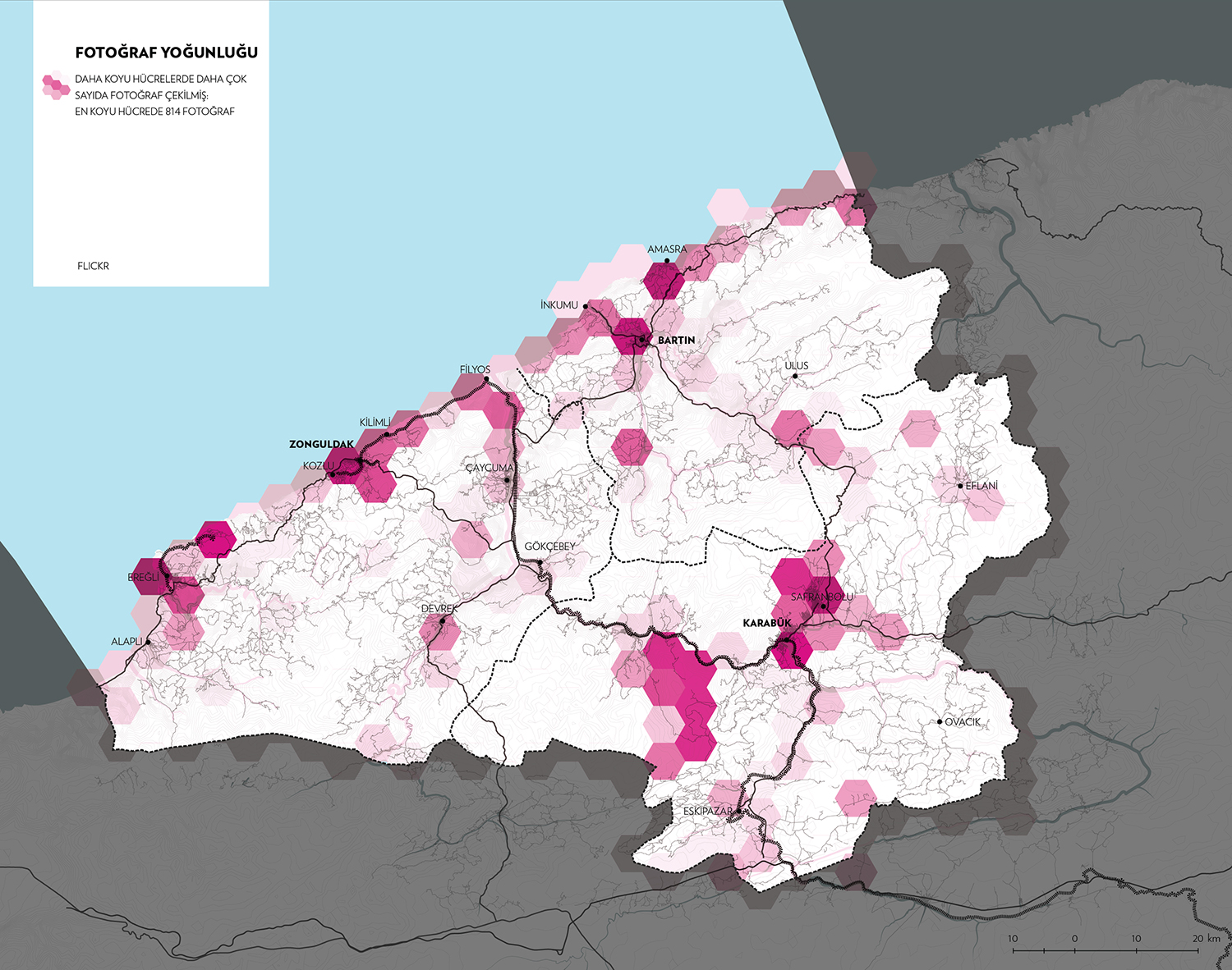
Where there are a higher amount of Flickr photos shared.
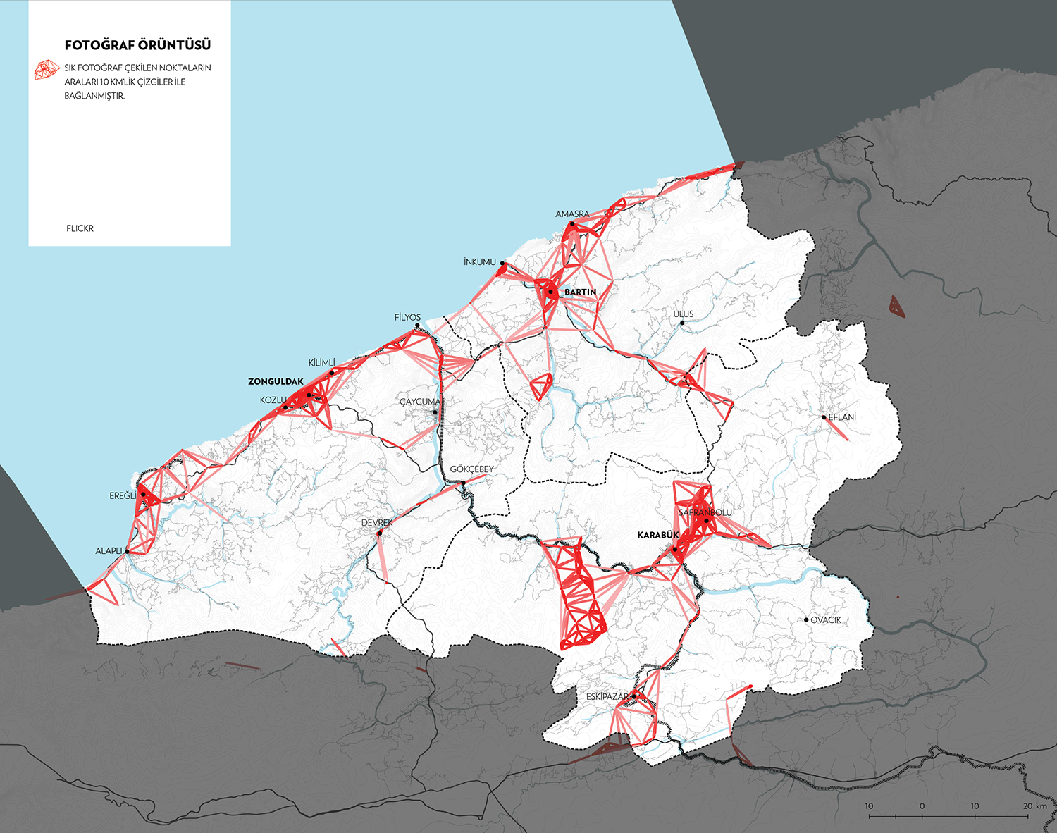
Network of share Flickr photos.

Bike routes; from Wikiloc.

Hiking and other outdoor routes; from Wikiloc.

ATV, enduro, motorbike and offroad routes; from Wikiloc.
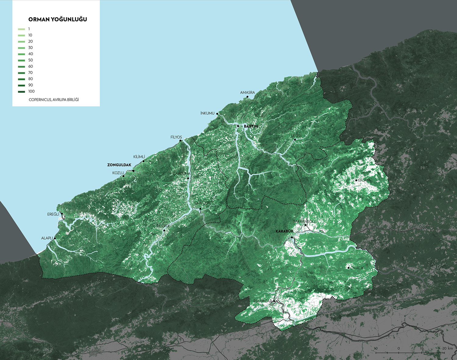
Forest density; from copernicus.eu